Welwyn Garden City — Hertford
Welher two

Slow Way not verified yet. Verify Welher here.
Slow Way not verified yet. Verify Welher here.
By Colin Rice on 29 Jan 2022
Description
Welher one is probably the best cycling route between Welwyn and Hertford, but an alternative that may be more interesting for walkers is to go through Panshanger Park. There are three or four kissing gates in Panshanger Park but this route could be cycled as well.
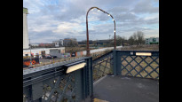
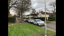
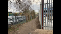
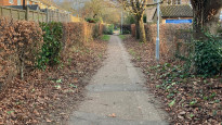
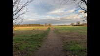
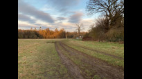
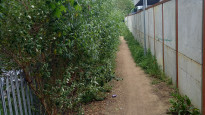
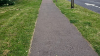
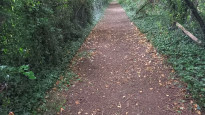
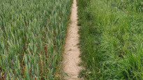
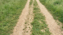
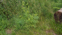
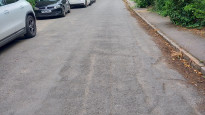
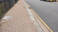
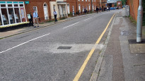
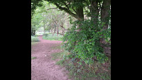
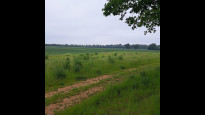
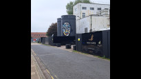
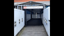
Leave the station via the footbridge taking the sign for Broadwater (photo 1). Turn right at the bottom of the footbridge stairs onto Hydeway, passing the old Shredded Wheat factory. Cross Broadwater Road and continue on Hydeway to Peartree Lane. Cross over and turn left onto Ravensfield Road - a slightly confusing junction (photo 2). Follow this to Bridge Road East and cross over onto Swallowfields, the B+Q store on your left (photo 3). Take the first right turn and then left immediately into Swallow End. This leads down to what remains of the railway between Welwyn and Hertford which is sadly no longer continuous as a route - what shortsightedness (photo 4). Instead the path crosses over it and leads to Watchmead. Turn right and follow Watchmead as it winds left (photo 5) and joins Black Fan Road (photo 6). The next section is rather dull for walkers: press on along Black Fan Road for 500m, passing two junctions on the way, till you reach Panshanger Drive. The entrance to Morrisons is on the right. Turn left onto Panshanger Drive and follow it for about 400m, crossing to the other side at a suitable crossing point . Just before the large roundabout, take the signed footpath to the right (photo 7). This is a pleasant leafy path that runs behind houses (photo 8). Cross Sylvan Way and continue in the same direction. After about 200m the path swings left, crosses Dalewood, a quiet cul de sac, then curves to the right past allotments before arriving at a track and a hedge which marks the edge of the town (photo 9). Carry straight on, across a field, past or through a wood (photo 10), and across another field, all on a well used path, until you reach Panshanger Lane.
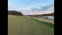
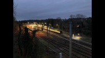
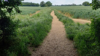
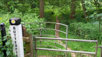
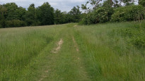
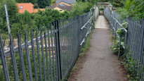
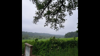
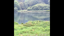
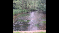
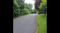
Turn left and follow the road for 500m till you reach a gate into Panshanger Park (photo 11). There is a separate kissing gate marked 'Butterfield Way'. (This road section could be avoided by taking paths through the woods but they are not marked as public rights of way.) The paths in the Park on the other hand are permissive paths and this is completely safe, quiet and delightful. The path joins the main track, passes a timber barn, then as the track swings left you want to carry on in the same direction over rough grass down the slope (photo 12). The path follows the south side of the River Mimram and lake until it reaches a gate. Turn left here, cross the river, and at Riverside Cottage with its noisy generator turn right through a kissing gate. The path ahead is a broad stretch of open grassland (photo 13) and eventually comes to a large timber kissing gate into the car park serving the Park. Go through this onto Thieves Lane, turn right down to the busy A414 roundabout, turn left, and after a few yards take the path on the left leading up to the remains of Old Hertingfordbury Road (photo 14). After about 120m, there is footpath signed on the left that climbs steeply up the hill. Take this and follow it round to the right. The path runs between back gardens with good views across the town. After about 700m, it curves to the left and there is a right turn across a footbridge over the railway with Hertford North station down below (photo 15). Follow the path till it joins Royston Close, turn left onto Sele Road down to North Road. Turn right onto North Road and carry on into the centre of Hertford via St Andrews Street, The Wash and Maidenhead Street. The rest of the route to Hertford East station is through the town
Welher one is probably the best cycling route between Welwyn and Hertford, but an alternative that may be more interesting for walkers is to go through Panshanger Park. There are three or four kissing gates in Panshanger Park but this route could be cycled as well.
Leave the station via the footbridge taking the sign for Broadwater (photo 1). Turn right at the bottom of the footbridge stairs onto Hydeway, passing the old Shredded Wheat factory. Cross Broadwater Road and continue on Hydeway to Peartree Lane. Cross over and turn left onto Ravensfield Road - a slightly confusing junction (photo 2). Follow this to Bridge Road East and cross over onto Swallowfields, the B+Q store on your left (photo 3). Take the first right turn and then left immediately into Swallow End. This leads down to what remains of the railway between Welwyn and Hertford which is sadly no longer continuous as a route - what shortsightedness (photo 4). Instead the path crosses over it and leads to Watchmead. Turn right and follow Watchmead as it winds left (photo 5) and joins Black Fan Road (photo 6). The next section is rather dull for walkers: press on along Black Fan Road for 500m, passing two junctions on the way, till you reach Panshanger Drive. The entrance to Morrisons is on the right. Turn left onto Panshanger Drive and follow it for about 400m, crossing to the other side at a suitable crossing point . Just before the large roundabout, take the signed footpath to the right (photo 7). This is a pleasant leafy path that runs behind houses (photo 8). Cross Sylvan Way and continue in the same direction. After about 200m the path swings left, crosses Dalewood, a quiet cul de sac, then curves to the right past allotments before arriving at a track and a hedge which marks the edge of the town (photo 9). Carry straight on, across a field, past or through a wood (photo 10), and across another field, all on a well used path, until you reach Panshanger Lane.
Turn left and follow the road for 500m till you reach a gate into Panshanger Park (photo 11). There is a separate kissing gate marked 'Butterfield Way'. (This road section could be avoided by taking paths through the woods but they are not marked as public rights of way.) The paths in the Park on the other hand are permissive paths and this is completely safe, quiet and delightful. The path joins the main track, passes a timber barn, then as the track swings left you want to carry on in the same direction over rough grass down the slope (photo 12). The path follows the south side of the River Mimram and lake until it reaches a gate. Turn left here, cross the river, and at Riverside Cottage with its noisy generator turn right through a kissing gate. The path ahead is a broad stretch of open grassland (photo 13) and eventually comes to a large timber kissing gate into the car park serving the Park. Go through this onto Thieves Lane, turn right down to the busy A414 roundabout, turn left, and after a few yards take the path on the left leading up to the remains of Old Hertingfordbury Road (photo 14). After about 120m, there is footpath signed on the left that climbs steeply up the hill. Take this and follow it round to the right. The path runs between back gardens with good views across the town. After about 700m, it curves to the left and there is a right turn across a footbridge over the railway with Hertford North station down below (photo 15). Follow the path till it joins Royston Close, turn left onto Sele Road down to North Road. Turn right onto North Road and carry on into the centre of Hertford via St Andrews Street, The Wash and Maidenhead Street. The rest of the route to Hertford East station is through the town
Status
This route has been reviewed by 2 people.
There are no issues flagged.
Photos for Welher two


Photos of this route will appear when they are added to a review. You can review this route here.
Information
Route status - Live
Reviews - 2
Average rating -
Is this route good enough? - Yes (2)
There are currently no problems reported with this route.
Downloads - 8
Surveys
What is this route like?
Surveys are submitted by fellow users of this website and show what you might expect from this Slow Ways route. Scroll down the page to read more detailed surveys.
| Grade 3X based on 1 surveys | Sign up or log in to survey this route. | ||
|---|---|---|---|
| Description | Note | ||
| Grade 3: Route includes rough surfaces that may include small boulders, potholes, shallow ruts, loose gravel, short muddy sections. Access grade X: At least one stile, flight of steps or other obstacle that is highly likely to block access for wheelchair and scooter users. |
Grading is based on average scores by surveyors. This slow way has 1 surveys. | ||
| Full grading description | |||
Only people who have completed our training can become Slow Ways surveyors and submit a survey. We do not vet contributors, so we cannot guarantee the quality or completeness of the surveys they complete. If you are dependent on the information being correct we recommend reading and comparing surveys before setting off.
Survey Photos
Facilities
Facilities in the middle third of this route.
Challenges
Potential challenges reported on this route. Some challenges are seasonal.
Obstacles
Obstacles on this route.
Accessibility
Is this route step and stile free?
Measurements
Surveyors were asked to measure the narrowest and steepest parts of paths.
The narrowest part of the path is 50.0cm (1)
The steepest uphill gradient walking East 10.0% (1)
The steepest uphill gradient walking West 11.0% (1)
The steepest camber gradient across the path 5.0% (1)
How clear is the waymarking on the route: Unsigned (1)
Successfully completed
We asked route surveyors "Have you successfully completed this route with any of the following? If so, would you recommend it to someone with the same requirements?". Here is how they replied.
Recommended by an expert
We asked route surveyors "Are you a trained access professional, officer or expert? If so, is this route suitable for someone travelling with any of the following?" Here is how they replied.
Terrain
We asked route surveyors to estimate how much of the route goes through different kinds of terrain.
There is no data on how much of this route is on roads
There is no data on how much of this route is lit at night
Thereis no data on amount of route paved
There is no data on muddiness
There is no data on rough ground
There is no data on long grass
Report a problem with this data
1 surveys
Information from verified surveys.
Geography information system (GIS) data
Total length
Maximum elevation
Minimum elevation
Start and end points
Welwyn Garden City
Grid Ref
TL2394412898
Lat / Lon
51.80101° / -0.20389°
Easting / Northing
523,944E / 212,898N
What3Words
sits.emerge.gross
Hertford
Grid Ref
TL3297012917
Lat / Lon
51.79910° / -0.07306°
Easting / Northing
532,970E / 212,917N
What3Words
await.bend.march
| Welwyn Garden City | |
|---|---|
| Grid Ref | TL2394412898 |
| Lat / Lon | 51.80101° / -0.20389° |
| Easting / Northing | 523,944E / 212,898N |
| What3Words | sits.emerge.gross |
| Hertford | |
|---|---|
| Grid Ref | TL3297012917 |
| Lat / Lon | 51.79910° / -0.07306° |
| Easting / Northing | 532,970E / 212,917N |
| What3Words | await.bend.march |
Sorry Land Cover data is not currently available for this route. Please check back later.
reviews
Strider
08 Jun 2024I walked from Welwyn to Hertford.
The route is well described by Colin, and an excellent route it is. I would add that the kissing gates in Panhangers Park are not exactly on the marked route but hidden a few metres to the side, which I found a little confusing. Walking out of Welwyn was mundane, and the industrial estate ugly. The only other part I disliked was a short walk in Panhanger Lane, no pavement and a hop-onto-when -a car-comes type of verge not a walk-on-beside-the-road type of verge.
That said, the rest of the walk is stunning, varied, and very enjoyable. Paths are good, mud free, and easy to navigate. Lovely views across the countryside with benches to soak it all in. Lakes and the River Mimram add to the variety. Lots of wildlife, a spoonbill was the highlight for me. Going into Hertford via an undulating cut through avoided traffic for as long as possible. No village half way, but shops at either end and benches by the lakes to sit.
Stairs into Welwyn station, you could use the lifts on the west side but it's a long detour to get around to the east side again. Narrow paths with a camber and kissing gates would make it too difficulty for wheelchairs and buggies I think.
An excellent route through beautiful Hertfordshire countryside.
Christopher Lewis
21 May 2024I really enjoyed walking this route.
This is a route with a lot of variety.
From Hertford to Welwyn Garden City, it starts with a pleasant walk through Hertford Town centre. It sticks to pedestrianised areas and pavements.
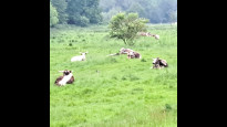
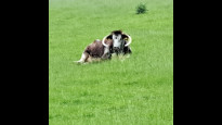
Just outside of Hertford, it ebters Panshanger Park. The section of walk across Panshanger is particularly scenic, across meadows and next to a lake. There were long-horned cattle grazing in one of the meadows I passed through.
Leaving the park, the route follows a road without a pavement for around 400 metres. It's not a particularly busy road but it is curved, so some care was required. It appeared as if there might have been alternative footpaths that would have avoided walking along the side of the road, but I can't be sure.
From the road, the route follows a very pleasant path along the headland of a field and past a copse of trees to reach the outskirts of Welwyn Garden City.
A dedicated footpath/cycle path takes you much of the way towards the town centre, although the last portion is along pavements in a warehouse area.
A footbridge (unfortunately not suitable for anyone who can't manage stairs) takes you across the railway line to the town centre.
-
Share your thoughts
Share your views about this route, give it a star rating, indicate whether it should be verified or not.
Include information that will be useful to others considering to walk or wheel it.
You can add up to 15 photos.
Other Routes for Welwyn Garden City—Hertford See all Slow Ways
Review this better route and help establish a trusted network of walking routes.
Suggest a better route if it better meets our methodology.
Share your thoughts