Description
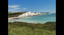
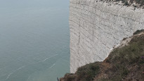
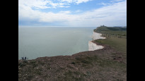
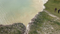
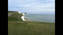
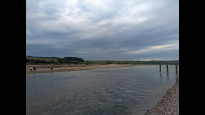
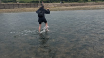
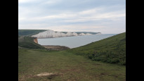
This has to be one of the most iconic walks in England which deserves to be in the Slow Ways catalogue. It takes in Seaford Head, Hope Gap, Cuckmere Haven, The Seven Sisters, Birling Gap, Belle Tout lighthouse and Beachy Head. Make sure you arrange to reach Cuckmere Haven at low tide, when you can take your shoes off and paddle across the river with the water ankle deep. This saves a 2 mile detour up the valley to cross the river at Exceat Bridge. In the summer you'll often see a Spitfire flying down the valley, over the coastguards cottages. Overall a bucket list experience
This has to be one of the most iconic walks in England which deserves to be in the Slow Ways catalogue. It takes in Seaford Head, Hope Gap, Cuckmere Haven, The Seven Sisters, Birling Gap, Belle Tout lighthouse and Beachy Head. Make sure you arrange to reach Cuckmere Haven at low tide, when you can take your shoes off and paddle across the river with the water ankle deep. This saves a 2 mile detour up the valley to cross the river at Exceat Bridge. In the summer you'll often see a Spitfire flying down the valley, over the coastguards cottages. Overall a bucket list experience
Status
This route has been reviewed by 3 people.
There are no issues flagged.
Photos for Seaeas three


.jpg)
.jpg)
.jpg)
.jpg)
.jpg)
.jpg)
.jpg)
.jpg)
.jpg)
.jpg)
.jpg)
.jpg)
.jpg)
.jpg)
.jpg)
.jpg)
.jpg)
.jpg)
.jpg)
.jpg)
Photos of this route will appear when they are added to a review. You can review this route here.
Information
")
Route status - Live
Reviews - 3
Average rating -
Is this route good enough? - Yes (3)
There are currently no problems reported with this route.
Downloads - 14
Surveys
What is this route like?
Surveys are submitted by fellow users of this website and show what you might expect from this Slow Ways route. Scroll down the page to read more detailed surveys.
| Grade 4X based on 1 surveys | Sign up or log in to survey this route. | ||
|---|---|---|---|
| Description | Note | ||
| Grade 4: Route includes very rough surfaces including deep ruts, steep loose gravel, unmade paths and deep muddy sections. Wheelchairs may experience traction/wheel spin issues. Access grade X: At least one stile, flight of steps or other obstacle that is highly likely to block access for wheelchair and scooter users. |
Grading is based on average scores by surveyors. This slow way has 1 surveys. | ||
| Full grading description | |||
Only people who have completed our training can become Slow Ways surveyors and submit a survey. We do not vet contributors, so we cannot guarantee the quality or completeness of the surveys they complete. If you are dependent on the information being correct we recommend reading and comparing surveys before setting off.
Survey Photos
Facilities
Facilities in the middle third of this route.
Challenges
Potential challenges reported on this route. Some challenges are seasonal.
Obstacles
Obstacles on this route.
Accessibility
Is this route step and stile free?
Measurements
Surveyors were asked to measure the narrowest and steepest parts of paths.
Narrowest part of path: no data
The steepest uphill gradient East: no data
The steepest uphill gradient walking West 18.0% (1)
The steepest camber: no data
How clear is the waymarking on the route: Clear (1)
Successfully completed
We asked route surveyors "Have you successfully completed this route with any of the following? If so, would you recommend it to someone with the same requirements?". Here is how they replied.
Recommended by an expert
We asked route surveyors "Are you a trained access professional, officer or expert? If so, is this route suitable for someone travelling with any of the following?" Here is how they replied.
Terrain
We asked route surveyors to estimate how much of the route goes through different kinds of terrain.
5.0% of the route is on roads (1)
5.0% of the route is lit at night (1)
5.0% of the route is paved (1)
10.0% of the route is muddy (1)
20.0% of the route is over rough ground (1)
There is no data on long grass
Report a problem with this data
1 surveys
Information from verified surveys.
Geography information system (GIS) data
Total length
Maximum elevation
Minimum elevation
Start and end points
Seaford
Grid Ref
TV4817999125
Lat / Lon
50.77278° / 0.10017°
Easting / Northing
548,179E / 99,125N
What3Words
boils.endings.costly
Eastbourne
Grid Ref
TV6097399104
Lat / Lon
50.76919° / 0.28147°
Easting / Northing
560,973E / 99,104N
What3Words
luck.cheese.natively
| Seaford | |
|---|---|
| Grid Ref | TV4817999125 |
| Lat / Lon | 50.77278° / 0.10017° |
| Easting / Northing | 548,179E / 99,125N |
| What3Words | boils.endings.costly |
| Eastbourne | |
|---|---|
| Grid Ref | TV6097399104 |
| Lat / Lon | 50.76919° / 0.28147° |
| Easting / Northing | 560,973E / 99,104N |
| What3Words | luck.cheese.natively |
Sorry Land Cover data is not currently available for this route. Please check back later.
reviews
CLIFF
10 Aug 2023An excellent walk along the chalk cliffs.
We walked east to west on a sunny August day, the walk is popular but the path is very wide so there is plenty of space.
The ascents and descents are quite steep, so caution would be needed in wet weather. We found the chalk paths that had been worn by earlier walkers to be crumbly, so in places we moved on to the grass to get extra grip.
Due to luck, the tide was out at Cuckmere River so lots of people were crossing rather than walking via Exceat. I stomped across in leather boots and got some water in them, but this was more comfortable for me than going bare foot over the pebbles, water shoes may be a good option if you want to keep your boots dry, but most people seemed happy to go bare foot.
There is very little shade on the route and few facilities so you should carry sufficient water.
The cliffs are unguarded, so young children and dogs need to be well supervised.
Ingrina
14 Nov 2022A beautiful route giving you endless views of white cliffs and ocean that also adds a bit of a challenge in the many ascents and descents you'll do! I didn't time this with low tide so had to take the detour inland, but it worked out fine since it was at the beginning of the walk (Seaford to Eastbourne direction) so I wasn't tired yet!
Did this in the summer, so there seemed to be quite a buzz in the area and enough facilities along the way. Be aware that this is quite exposed, so you won't get much shelter in any kind of weather. We went on a very hot day, meaning extra water and a much welcomed ice lolly from a van along the way.
-
Share your thoughts
Slow Ways Darren
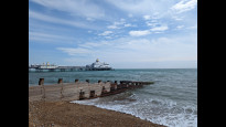
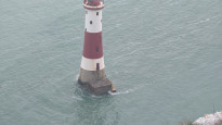
11 Jul 2022This has to be one of the most iconic walks in England but not recommended if you aren't good with heights. There are some very steep paths and very dangerous drops en route. We walked it the other way from Eastbourne to Seaford and it was very physically demanding. It takes you over the Beachy Head (and the kite flyers there) by the world famous Belle Tout Lighthouse and also over the Seven Sisters cliffs. It finally brings you back down to sea level at the atmospheric and otherworldly Cuckfield Haven.
At Cuckfield Haven you have to careful / clever and consult the tide tables as the Cuckmere River is tidal and sometimes too high to cross. You'll definitely have to get your feet wet unless you take an extra 3k walk up the river and then go into Seaford along the main road. Seaford itself had a great approach with some adventurous steep paths to get down to the flat and accessible sea front. There are great options for pubs and food at Seaford and Eastbourne with a train station at each end. The only other refreshment break is midway at the Birling Gap lighthouse, so make sure you take supplies.
-

Bostal Boy
12 Jul 2022Glad you enjoyed it!
-
Share your thoughts
Share your views about this route, give it a star rating, indicate whether it should be verified or not.
Include information that will be useful to others considering to walk or wheel it.
You can add up to 15 photos.
Other Routes for Seaford—Eastbourne See all Slow Ways
Review this better route and help establish a trusted network of walking routes.
Suggest a better route if it better meets our methodology.
Share your thoughts