Description
This is a Slow Ways route connecting Polegate and Bexhill.
Know of a better route? Share it here.
This is a Slow Ways route connecting Polegate and Bexhill.
Know of a better route? Share it here.
Status
This route has been reviewed by 1 person.
There are no issues flagged.
Photos for Polbex one


Photos of this route will appear when they are added to a review. You can review this route here.
Information

Route status - Live
Reviews - 1
Average rating -
Is this route good enough? - Yes (1)
There are currently no problems reported with this route.
Downloads - 3
Surveys
We are working to build-up a picture of what routes look like. To do that we are asking volunteers to survey routes so that we can communicate features, obstacles and challenges that may make a route desirable or not.
Slow Ways surveyors are asked to complete some basic online training, but they are not vetted. If you are dependent on the survey information being correct in order to complete a route, we recommend that you think critically about the information provided. You may also wish to wait until more than one survey has been completed.
Help people know more about this route by volunteering to submit a survey.
- Complete the survey training.
- Submit a survey for this route.
Geography information system (GIS) data
Total length
Maximum elevation
Minimum elevation
Start and end points
Polegate
Grid Ref
TQ5819304818
Lat / Lon
50.82130° / 0.24454°
Easting / Northing
558,193E / 104,818N
What3Words
broad.reds.flag
Bexhill
Grid Ref
TQ7450007539
Lat / Lon
50.84106° / 0.47712°
Easting / Northing
574,500E / 107,539N
What3Words
keeps.caves.turkey
Polbex One's land is
| Polegate | |
|---|---|
| Grid Ref | TQ5819304818 |
| Lat / Lon | 50.82130° / 0.24454° |
| Easting / Northing | 558,193E / 104,818N |
| What3Words | broad.reds.flag |
| Bexhill | |
|---|---|
| Grid Ref | TQ7450007539 |
| Lat / Lon | 50.84106° / 0.47712° |
| Easting / Northing | 574,500E / 107,539N |
| What3Words | keeps.caves.turkey |
| Arable | 16.3% |
| Intertidal flats | 13.0% |
| Pasture | 53.0% |
| Urban | 17.7% |
Data: Corine Land Cover (CLC) 2018
review
Bostal Boy
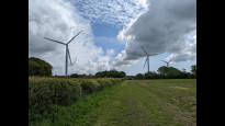
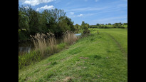
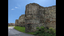
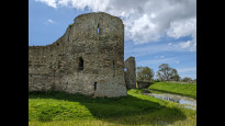
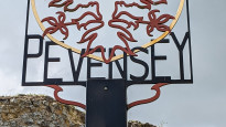
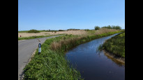
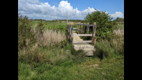
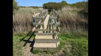
15 May 2023I pioneered this route which has a railway station at either end on 11th May. I really enjoyed this one. It heads quickly out of Polegate using the National Cycle Network paths so is well surfaced until it crosses the A27 over a good bridge. It then moves onto field paths and country lanes across the Pevensey Levels. This includes the glorious section of the 1066 Country Walk beside the Pevensey Haven from Rickney Farm to Pevensey. The castle at Pevensey is well worth a stop with plenty of benches inside the outer bailey which is free to enter. There are other pubs and cafes in Pevensey village outside the castle walls.
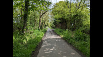
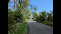
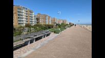
From Pevensey to Normans Bay the route uses an unclassified road which is unfortunately not free of traffic. There are usually verges to step onto to get out of the way of the cars which can be seen and heard well before they get to you. It is a better route for cyclists than pedestrians, although the views across the Levels here are very nice. From the Star pub at Normans Bay you are back on footpaths across fields and a golf course to Cooden Beach. All easy to follow, but usually cattle or sheep in the fields. From Cooden Beach to Bexhill, the route is along the seashore. Initially this is walking across shingle at the top of the beach (or sand lower down if the tide is out). Then after about a half mile you reach the start of the Bexhill promenade which goes all the way to the De La Warr Pavilion. From there it is a short walk through the town centre to the railway station and the finish. Bexhill prom has all the usual seaside facilities e.g. cafes and public WCs.
This is a good route, well marked on the map and pretty easy to follow on the ground - especially with sat nav. There is a bit too much road walking between Pevensey and Normans Bay, but I'm still going to give the route 5*.
Share your views about this route, give it a star rating, indicate whether it should be verified or not.
Include information that will be useful to others considering to walk or wheel it.
You can add up to 15 photos.
There are no other routes for Polegate — Bexhill
If you know a better way, then please let us know.
Review this better route and help establish a trusted network of walking routes.
Suggest a better route if it better meets our methodology.
Share your thoughts