Description
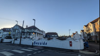
Paignton to Torquay
Paignton to Torquay
Status
This route has been reviewed by 3 people.
There are no issues flagged.
Photos for Paitor one


Photos of this route will appear when they are added to a review. You can review this route here.
Information
")
Route status - Live
Reviews - 3
Average rating -
Is this route good enough? - Yes (3)
There are currently no problems reported with this route.
Downloads - 7
Surveys
We are working to build-up a picture of what routes look like. To do that we are asking volunteers to survey routes so that we can communicate features, obstacles and challenges that may make a route desirable or not.
Slow Ways surveyors are asked to complete some basic online training, but they are not vetted. If you are dependent on the survey information being correct in order to complete a route, we recommend that you think critically about the information provided. You may also wish to wait until more than one survey has been completed.
Help people know more about this route by volunteering to submit a survey.
- Complete the survey training.
- Submit a survey for this route.
Geography information system (GIS) data
Total length
Maximum elevation
Minimum elevation
Start and end points
Paignton
Grid Ref
SX8893960596
Lat / Lon
50.43466° / -3.56519°
Easting / Northing
288,939E / 60,596N
What3Words
linen.holds.filled
Torquay
Grid Ref
SX9053863487
Lat / Lon
50.46095° / -3.54352°
Easting / Northing
290,538E / 63,487N
What3Words
stability.sectors.extra
| Paignton | |
|---|---|
| Grid Ref | SX8893960596 |
| Lat / Lon | 50.43466° / -3.56519° |
| Easting / Northing | 288,939E / 60,596N |
| What3Words | linen.holds.filled |
| Torquay | |
|---|---|
| Grid Ref | SX9053863487 |
| Lat / Lon | 50.46095° / -3.54352° |
| Easting / Northing | 290,538E / 63,487N |
| What3Words | stability.sectors.extra |
Sorry Land Cover data is not currently available for this route. Please check back later.
reviews
Danravenellison
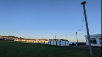
19 Jan 2023I enjoyed walking this route as the sun was setting.
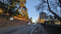
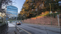
Walking along the coast is great and there are some great views across Torbay. The bit along the A379 is a shame, but it's not that long in the scheme of things. I'd probably not travel to walk this route just for the fun of it without combining it with one of the connecting Slow Ways... but if I was in Paignton or Torquay I'd enjoy walking it again to get to the other.
Someone local might be able to suggest another route that's longer and skips the A379.
Pav
24 Dec 2021First half of walk is along main road and on a summer’s day was hot and noisy. On reaching outskirts of Preston route drops down through park to marine parade and promenade. If tide is out, it is possible to walk along beach to pier and Paignton sands. Numerous routes through town to railway station.
-
Share your thoughts
PaulHutchinson
26 Apr 2021Walked this route from Torquay to Paignton. Approximately the first half is along side a busy road with a good footpath pavement although there’s a pinch point where the road and shared cycle & footpath have a pinch point reducing the path to around one metre fifty. A pleasant enough walk between the two town with the only hiccup being the current (hopefully temporary) closure of Garfield Road, but this can be bypassed using the parallel Beach Road to the south.
-
Share your thoughts
Share your views about this route, give it a star rating, indicate whether it should be verified or not.
Include information that will be useful to others considering to walk or wheel it.
You can add up to 15 photos.
There are no other routes for Paignton — Torquay
If you know a better way, then please let us know.
Review this better route and help establish a trusted network of walking routes.
Suggest a better route if it better meets our methodology.
Share your thoughts