Description
I designed this from my desktop as an alternative to the very tedious looking LivPre 1. I haven't tested it in real life yet. Aimed at methodology items 5 and 9!
I designed this from my desktop as an alternative to the very tedious looking LivPre 1. I haven't tested it in real life yet. Aimed at methodology items 5 and 9!
Status
This route has been reviewed by 2 people.
There are no issues flagged.
Photos for Livpre two


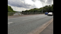

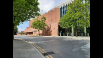
Photos of this route will appear when they are added to a review. You can review this route here.
Information

Route status - Live
Reviews - 2
Average rating -
Is this route good enough? - Yes (2)
There are currently no problems reported with this route.
Downloads - 1
Surveys
What is this route like?
Surveys are submitted by fellow users of this website and show what you might expect from this Slow Ways route. Scroll down the page to read more detailed surveys.
| Grade 1X based on 1 surveys | Sign up or log in to survey this route. | ||
|---|---|---|---|
| Description | Note | ||
| Grade 1: Entirely smooth and compacted surfaces. Access grade X: At least one stile, flight of steps or other obstacle that is highly likely to block access for wheelchair and scooter users. |
Grading is based on average scores by surveyors. This slow way has 1 surveys. | ||
| Full grading description | |||
Only people who have completed our training can become Slow Ways surveyors and submit a survey. We do not vet contributors, so we cannot guarantee the quality or completeness of the surveys they complete. If you are dependent on the information being correct we recommend reading and comparing surveys before setting off.
Survey Photos
Facilities
Facilities in the middle third of this route.
Challenges
Potential challenges reported on this route. Some challenges are seasonal.
Obstacles
Obstacles on this route.
Accessibility
Is this route step and stile free?
Measurements
Surveyors were asked to measure the narrowest and steepest parts of paths.
The narrowest part of the path is 40.0cm (1)
The steepest uphill gradient East: no data
The steepest uphill gradient West: no data
The steepest camber: no data
How clear is the waymarking on the route: Unclear in places (1)
Successfully completed
We asked route surveyors "Have you successfully completed this route with any of the following? If so, would you recommend it to someone with the same requirements?". Here is how they replied.
Recommended by an expert
We asked route surveyors "Are you a trained access professional, officer or expert? If so, is this route suitable for someone travelling with any of the following?" Here is how they replied.
Terrain
We asked route surveyors to estimate how much of the route goes through different kinds of terrain.
There is no data on how much of this route is on roads
There is no data on how much of this route is lit at night
100.0% of the route is paved (1)
There is no data on muddiness
There is no data on rough ground
There is no data on long grass
Report a problem with this data
1 surveys
Information from verified surveys.
Geography information system (GIS) data
Total length
Maximum elevation
Minimum elevation
Start and end points
Liverpool
Grid Ref
SJ3502190540
Lat / Lon
53.40767° / -2.97892°
Easting / Northing
335,021E / 390,540N
What3Words
twice.email.bleak
Prescot
Grid Ref
SJ4651592765
Lat / Lon
53.42896° / -2.80642°
Easting / Northing
346,515E / 392,765N
What3Words
focal.desks.skin
| Liverpool | |
|---|---|
| Grid Ref | SJ3502190540 |
| Lat / Lon | 53.40767° / -2.97892° |
| Easting / Northing | 335,021E / 390,540N |
| What3Words | twice.email.bleak |
| Prescot | |
|---|---|
| Grid Ref | SJ4651592765 |
| Lat / Lon | 53.42896° / -2.80642° |
| Easting / Northing | 346,515E / 392,765N |
| What3Words | focal.desks.skin |
Sorry Land Cover data is not currently available for this route. Please check back later.
reviews
Hiking Historian
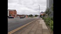
16 Jun 2023Whilst the first route is more direct, it did stick to major roads. This route, however, swerves these nosier highways and heads down quiter, and more enjoyable, roads and footpaths so that we mostly avoid the din of traffic.
It begins on major roads, however; well-paved and with good crossings from Lime Street to just beyond Low Hill. Here we leave the main road and head down residential and shopping streets in some of Liverpool's most multicultural neighbourhoods.
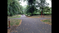
Passing into Newsham Park, we have a brief green interlude before we hit more residential streets once more. After a few turns, and crossing Queens Drive, we eventually find our way onto the Liverpool Loop Line on the wonderful West Derby cutting, a quiet and peaceful walk carved from stone on a disused railway.
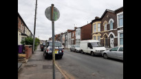
We're not on it too long, unfortunately, as we head, once more, along residential roads and past a series of schools. Once past these, a footpath across a meadow, and then, behind houses before walking alongside the river Alt. At its end, another major road (A57), before once more finding ourselves on quieter roads, parks, before eventually finding ourselves in Prescot.
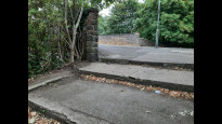
Although there are good park sections, this is still a street slog, but through much quiter sections than the original. Well-paved throughout, with footpaths tarmacced, paved or loose stone. Some sections may not be wheelchair friendly (high kerbs; no ramps, especially in the quiter more residential areas, and steps from Newsham Park onto Lister Drive), but otherwise good for all users.
Shops at both ends, and along the route; and goid transport links at both ends.
A solid urban route.
Mary Oz
05 Sep 2022The first mile is a busy main road, and a slightly uphill slog, but with good surfaces and crossings, then there is a dull but quieter road. It is nice to arrive at the pleasant Newsham Park. There are a few shallow steps on leaving the park to cross the railway bridge, although these could be avoided by following the road around. Another fairly quiet road takes you through some slightly faded-glory housing of Tuebrook. At the dual carriageway, a third of the way, there is an opportunity to buy food and coffee, before accessing the Liverpool Loop Line cycle track. This was the highlight of the walk for me - a small oasis approached from a former station. It followed a vertical, stratified-red-sandstone cutting, just like the Lime Street Station approach; it was cool and peaceful but you hear people above sometimes.
This was followed by more suburban roads past Alder Hey Children’s Hospital, several schools, and a golf course. There were more shops here, near halfway, but this section was a bit long and tedious.
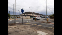
With about 4 miles still to go, the route entered a mile-and-a-half section of off-road cycle track (with several cycle barriers) through urban fields and alongside a stream. On reaching another main road there were some more shops and a pub. Soon the route crossed some playing fields, then there was another busy road, with cars parked fully on the wide pavement. I hardly noticed crossing over the motorway with so much road traffic noise already, and crossing at the roundabout just after this not that easy, but it was good to reach a quieter road again. The final section into Prescot was quite nice, heading up an old footpath alongside the church.
The route was entirely hard surfaced, so it was reasonably accessible for most, bearing in mind the cycle barriers, but tiring for the feet. Although it is longer than LivPre One, there are many breaks away from busy roads in what is otherwise a completely built-up urban area.
-
Share your thoughts
Share your views about this route, give it a star rating, indicate whether it should be verified or not.
Include information that will be useful to others considering to walk or wheel it.
You can add up to 15 photos.
Other Routes for Liverpool—Prescot See all Slow Ways
Review this better route and help establish a trusted network of walking routes.
Suggest a better route if it better meets our methodology.
Share your thoughts