Description
Similar to LanCar One but avoiding the nasty footpath, and also using a slightly shorter section from Barley Cop Woods to the canal
Similar to LanCar One but avoiding the nasty footpath, and also using a slightly shorter section from Barley Cop Woods to the canal
Status
This route has been reviewed by 3 people.
There are no issues flagged.
Photos for Lancar two


Photos of this route will appear when they are added to a review. You can review this route here.
Information
")
Route status - Live
Reviews - 3
Average rating -
Is this route good enough? - Yes (3)
There are currently no problems reported with this route.
Downloads - 2
Surveys
What is this route like?
Surveys are submitted by fellow users of this website and show what you might expect from this Slow Ways route. Scroll down the page to read more detailed surveys.
| Grade 3X based on 1 surveys | Sign up or log in to survey this route. | ||
|---|---|---|---|
| Description | Note | ||
| Grade 3: Route includes rough surfaces that may include small boulders, potholes, shallow ruts, loose gravel, short muddy sections. Access grade X: At least one stile, flight of steps or other obstacle that is highly likely to block access for wheelchair and scooter users. |
Grading is based on average scores by surveyors. This slow way has 1 surveys. | ||
| Full grading description | |||
Only people who have completed our training can become Slow Ways surveyors and submit a survey. We do not vet contributors, so we cannot guarantee the quality or completeness of the surveys they complete. If you are dependent on the information being correct we recommend reading and comparing surveys before setting off.
Survey Photos
Facilities
Facilities in the middle third of this route.
Challenges
Potential challenges reported on this route. Some challenges are seasonal.
Obstacles
Obstacles on this route.
Accessibility
Is this route step and stile free?
Measurements
Surveyors were asked to measure the narrowest and steepest parts of paths.
The narrowest part of the path is 90.0cm (1)
The steepest uphill gradient walking East 14.0% (1)
The steepest uphill gradient walking West 12.0% (1)
The steepest camber gradient across the path 12.0% (1)
How clear is the waymarking on the route: Unclear in places (1)
Successfully completed
We asked route surveyors "Have you successfully completed this route with any of the following? If so, would you recommend it to someone with the same requirements?". Here is how they replied.
Recommended by an expert
We asked route surveyors "Are you a trained access professional, officer or expert? If so, is this route suitable for someone travelling with any of the following?" Here is how they replied.
Terrain
We asked route surveyors to estimate how much of the route goes through different kinds of terrain.
8.0% of the route is on roads (1)
9.0% of the route is lit at night (1)
8.0% of the route is paved (1)
2.0% of the route is muddy (1)
4.0% of the route is over rough ground (1)
There is no data on long grass
Report a problem with this data
1 surveys
Information from verified surveys.
Geography information system (GIS) data
Total length
Maximum elevation
Minimum elevation
Start and end points
Lancaster
Grid Ref
SD4718261726
Lat / Lon
54.04879° / -2.80819°
Easting / Northing
347,182E / 461,726N
What3Words
lace.tight.agree
Carnforth
Grid Ref
SD4981470640
Lat / Lon
54.12916° / -2.76948°
Easting / Northing
349,814E / 470,640N
What3Words
ramps.race.loudness
| Lancaster | |
|---|---|
| Grid Ref | SD4718261726 |
| Lat / Lon | 54.04879° / -2.80819° |
| Easting / Northing | 347,182E / 461,726N |
| What3Words | lace.tight.agree |
| Carnforth | |
|---|---|
| Grid Ref | SD4981470640 |
| Lat / Lon | 54.12916° / -2.76948° |
| Easting / Northing | 349,814E / 470,640N |
| What3Words | ramps.race.loudness |
Sorry Land Cover data is not currently available for this route. Please check back later.
reviews
Jackie
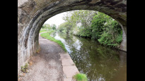
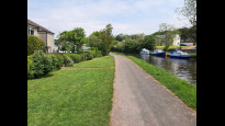
05 Nov 2023The start of the route was an interesting part of the city going under and over the railway and finally over the Lune out of the city. We soon reached the Lancaster canal which was a very scenic and beautiful stroll through some miles of open countryside with great views over the coast. The route comes to an end in the town of Carnforth at a small square very close to the railway. We were blessed with a wonderful sunny autumnal day for the whole walk.
Lancaster Ramblers
25 Jun 2021The route is as described by Mary Oz. It heads due north following the railway through a meadow, then goes over the River Lune using Carlisle railway bridge which at 1.2m wide may be a bit narrow. It then proceeds through Rylands park and some residential streets until it reaches the delightful Barley Cop Wood There is then a quiet farm road which leads to the canal. The bulk (70%) of the route follows the Lancaster Canal and is very pleasant and easy. The first half of this is mainly rural, and the second half pleasant suburban. The towpath is generally degraded tarmac. There are shops and refreshments in both Hest Bank and Bolton-le-Sands before reaching Carnforth. The Royal Hotel pub, Bolton-le-Sands ,has access from the towpath.
-
Share your thoughts
Mary Oz
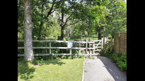
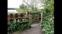
01 Jun 2021 (edited 05 Nov 2023)The route starts by following the railway through a meadow, then goes over the River Lune using a bridge with many steps up then many steps down. It then proceeds through the park and some residential roads until it reaches Barley Cop Wood which is well-maintained and lovely. There is a quiet farm road which reaches the canal. This is slightly shorter and quieter than LanCar One’s route alongside the M6 link road (Bay Gateway) although you don’t get the great 360⁰ panorama. The bulk (70%) of the route follows the Lancaster Canal and is very pleasant and easy. The first half of this is mainly rural, and the second half pleasant suburban. The towpath is generally degraded tarmac. At the half way point there is the Hest Bank Hotel (for refreshments and toilets) as well as other shops and pubs nearby.
-
Share your thoughts
Share your views about this route, give it a star rating, indicate whether it should be verified or not.
Include information that will be useful to others considering to walk or wheel it.
You can add up to 15 photos.
Other Routes for Lancaster—Carnforth See all Slow Ways
Review this better route and help establish a trusted network of walking routes.
Suggest a better route if it better meets our methodology.
Share your thoughts