Description
This is a Slow Ways route connecting Holt and Aylsham.
Know of a better route? Share it here.
This is a Slow Ways route connecting Holt and Aylsham.
Know of a better route? Share it here.
Status
This route has been reviewed by 3 people.
This route has been flagged (1 times) for reasons relating to access.
Photos for Holayl one


Photos of this route will appear when they are added to a review. You can review this route here.
Information

Route status - Live
Reviews - 3
Average rating -
Is this route good enough? - Yes (2) Maybe (1)
Problems reported - Access (1)
Downloads - 12
Surveys
We are working to build-up a picture of what routes look like. To do that we are asking volunteers to survey routes so that we can communicate features, obstacles and challenges that may make a route desirable or not.
Slow Ways surveyors are asked to complete some basic online training, but they are not vetted. If you are dependent on the survey information being correct in order to complete a route, we recommend that you think critically about the information provided. You may also wish to wait until more than one survey has been completed.
Help people know more about this route by volunteering to submit a survey.
- Complete the survey training.
- Submit a survey for this route.
Geography information system (GIS) data
Total length
Maximum elevation
Minimum elevation
Start and end points
Holt
Grid Ref
TG0794538748
Lat / Lon
52.90594° / 1.09072°
Easting / Northing
607,945E / 338,748N
What3Words
deferring.tasks.commander
Aylsham
Grid Ref
TG1931226911
Lat / Lon
52.79519° / 1.25151°
Easting / Northing
619,312E / 326,911N
What3Words
plug.cyber.addicted
Holayl One's land is
| Holt | |
|---|---|
| Grid Ref | TG0794538748 |
| Lat / Lon | 52.90594° / 1.09072° |
| Easting / Northing | 607,945E / 338,748N |
| What3Words | deferring.tasks.commander |
| Aylsham | |
|---|---|
| Grid Ref | TG1931226911 |
| Lat / Lon | 52.79519° / 1.25151° |
| Easting / Northing | 619,312E / 326,911N |
| What3Words | plug.cyber.addicted |
| Arable | 57.9% |
| Pasture | 15.5% |
| Urban | 14.4% |
| Woods | 12.1% |
Data: Corine Land Cover (CLC) 2018
reviews
Abi
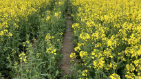
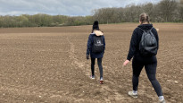
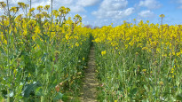
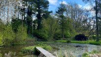
27 Apr 2023The route includes a mixture of public footpaths, restricted byways, bridleways, fields, through national trust parks and walking along the road (both quiet country roads and slightly busier main roads). Most paths were clear to see (whether paved, natural, asphalt etc) with the exception being where the route crossed through rapeseed fields which (due to the time of year) obscured the path due to the height/density of the plants. Due to rain the day prior, there were a few muddier sections that could be difficult to cross if unprepared.
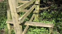
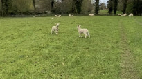
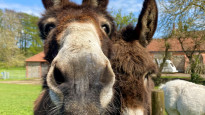
There were several kissing gates and stiles on the route and one small steep set of stairs needed to access the public footpath/field near Marlpit Road. Walkway to cross under the Holt bypass. The route also included crossing through areas with livestock (sheep, horses, donkeys).
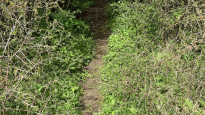
The GPX route included a couple of “off-grid segments” which, for the majority, were not an issue (eg where path was trying to direct us a few metres off to the side and then back onto the footpath further up, when we could see the footpath just continued straight – image attached to show). However, around Mackey’s Hill near Holt the route was trying to connect two points without a clear pathway between due to a chain fence blocking the way. We had to backtrack and divert by walking along the main road to reconnect with the planned route.
Overall, I would recommend the route with awareness around “off-grid” segments.
Hannah Ambridge
26 Apr 2023This walk has such a great mix of places to walk - fields, country roads, National Parks, woods etc. There's also so much wildlife to be seen too walking through fields of horses, donkeys, lambs! (All very used to seeing people so safe to walk passed)
All paths are walkable, typical country paths so not always level but not difficult either. The stiles and gates are all useable, some stiles even with special dog access to use!
I wouldn't say this is a dog friendly walk though as two fields are walking straight across rapeseed fields which is very dangerous for dogs.
The end of the walk (We done this backwards so Alysham to Holt) when the route gets to Holt Country park, the directions did get confused but I think this was due to it wanting us to go through a padlocked gate. It added on about 20 minutes for us to loop back round and divert onto the main road to actually finish but at least it's such a nice area to get a little lost in!
We had a great day on this route and the timing was exactly as it says - 5 hours 20 minutes.
Gave 4 stars only because of the route going slightly off track near the end and not being fully dog friendly but I would highly recommend :).
-
Share your thoughts
Norwich John
26 Apr 2023This is a good route with a mixture of farm fields, quiet roads and forestpaths. We walked this route in the opposite direction, so walking from Alysham to Holt. The route took us about 5 hours to walk, without stopping.
Things to be aware of there were animals in the fields near Fir plantation (sheep with lambs), horse and donkeys in a field near just before Hole Farm Road. All the animals weren’t bother by us walking through the fields.
Rapeseed – we walked through two fields where the rape seed plants had grown tall and were about 6 feet tall, the path although there was hidden by the plants.
There was a number of ‘kissing gates’ and Stiles on the route to climb over.
The main issue we faced was when we got to Holt Country Park, the GPX file wanted us to go through a 6 foot locked gate, after that we had walk along Hempsted Road to finish the route and get to Holt.
With the route confirmed would recommend.
-
Share your thoughts
Share your views about this route, give it a star rating, indicate whether it should be verified or not.
Include information that will be useful to others considering to walk or wheel it.
You can add up to 15 photos.
Other Routes for Holt—Aylsham See all Slow Ways
Review this better route and help establish a trusted network of walking routes.
Suggest a better route if it better meets our methodology.
Share your thoughts